This article describes how we planned our navigation details and used the Navigator‘s Notebook while we were cruising on Callipygia.
| 1. Passage Planning | 2. Passage Directions | 3. Navigation Calculations |
The Navigator's Notebook was a spiral notebook that we divided into two sections. At the front of the notebook, passage planning notes were made and passage directions developed. At the back of the notebook, navigation calculations and notes were made while underway.
We felt that it was really important to write everything down related to navigation while on passage, because it was too easy to make mistakes when we were tired--as we often were on an offshore passage. Near a coast, navigational errors are easy to make and can be deadly. The navigator's notebook worked well for us as a place to do our planning in a way that made for easy reference once we were underway.
When planning a new passage, the following information went into the front of navigator's notebook, 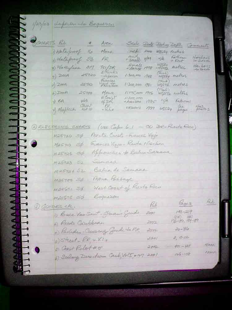 beginning on a new page. The date was put at the top along with the "from - to" for the passage being planned. Then, the information listed below was set out, in order. After the last element, a line was drawn across the page. While usually one person (on Callipygia it was Pat) will likely do most of this work, the others on the boat went through it so they were familiar with the upcoming passage's navigation issues and details. The real benefit of doing this formal compilation of information came because in order to write up these details we had to pull out our cruising resources and become familiar with the guidance in them. We also often found things that we needed to know for a passage, but would otherwise have overlooked.
As the navigator compiled this information, he/she also marked the route and waypoints on the chart(s). He/she flagged the waypoints on the chart with a small blue triangular flag cut from a roll of blue masking tape. The waypoint # was written on the flag in felt pen so it was easy to refer back to the waypoint list. On the margin of the chart, for each quadrant or section of the chart, the navigator mads a list of waypoints found on that quadrant, their GPS names, Lat/Lo, Cruising Guide page references, etc. Currents, commercial traffic routes, and other hazards were also described on the margin of the applicable chart quadrant and highlighted on the chart with a yellow marker.
The Navigator's Notebook was kept open and in the cockpit inside a plastic see-through sleeve while underway, so that it was easy to reference the waypoint list, hazard list, and passage directions, etc.
For a complex passage, on the next fresh page in the Navigator's Notebook, a series of passage directions were set out. These could be referred to in the future if the same passage was again to be traversed. At the bottom of the passage directions, a line was again drawn across the page. Passage directions for travel from Luperon to Boqueron is an example of this format. These pages were reviewed by everyone on board, together, at the start of a passage, and were then available as needed by whoever was on watch to remind them of the navigation details and issues as we went along.
The pages at the back of the notebook were used in conjunction with the Deck Log and charts when underway to document the boat's position as it progressed. Any position and current calculations and/or diagrams of set and drift (done on graph paper, then cut out), etc, etc. were written or pasted in the back of the Navigator's Notebook. At the start of a passage, the date was written at the top of a fresh page in the back of this notebook. Then as calculations, including celestial sight reductions if any, or diagrams were done, the author made and documented his or her calculation so that someone else could check them, if necessary--or he/she could go back and check for errors. After each calculation a short dashed line was drawn across the page. At the end of the passage a continuous line was drawn.